Public-safe reconstruction of a municipal road-safety engagement strategy
Vision Zero Public Engagement Strategy for Mississauga
Vision Zero is a global initiative to eliminate traffic deaths and serious injuries. This project turned local evidence into a targeted engagement strategy for Mississauga.
Project purpose
A broad safety goal still required targeted decisions.
The city needed to turn a shared road-safety goal into locally relevant engagement priorities for different places, road users, and communities.
Why targeted engagement was needed
General awareness communicated a common goal. Targeted engagement helped identify priority places and distinct communication needs.
How the project made targeting possible
The research connected collision patterns with geography and audience context to produce practical engagement inputs.
Selected analysis workstreams
I translated scattered evidence into decision-ready planning inputs.
The broader research included jurisdictional scanning and document review; the workstreams below focus on the analytical pieces most relevant to targeting, prioritization, and communication planning.
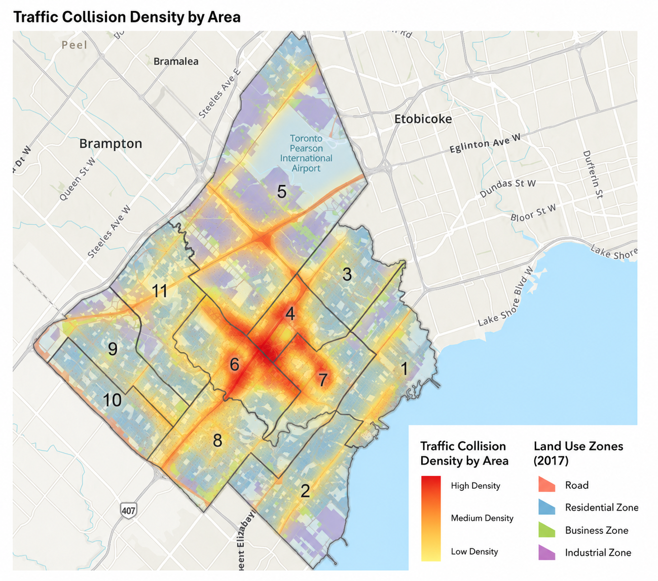
Where were collision incidents concentrated?
Collision records were geocoded and layered with wards and land-use context in QGIS. Density mapping preserved the relationship between incidents, road networks, neighbourhood boundaries, and surrounding uses in one spatial reading.
- Evidence
- Collision points, wards, land use
- Method
- Geocoding, QGIS density mapping, spatial overlays
What this enabled A spatial basis for discussing where place-based engagement could be most relevant.
How could age patterns shape audience planning?
Age-band profiling was paired with exploratory regression to assess how driver age related to recorded DUI collision counts.
- Evidence
- Age, road-user attributes, DUI collision counts
- Method
- Age-band profiling, distribution review, exploratory regression
What this enabled A defensible basis for considering differentiated audience approaches without treating age as a standalone risk score.
Public-safe analytical view
Age profile and directional test
Recorded-count association with distribution context
Exploratory linear model
Driver age and recorded DUI collision counts
Age coefficient
-0.054
per additional year
P-value
<0.001
statistically significant association
How could demographic data guide local outreach?
Census language variables were joined to ward geography, converted into comparable population shares, and classified consistently.
- Evidence
- Census language variables, ward boundaries
- Method
- Spatial joins, share calculation, standardized mapping
What this enabled A structured way to consider multilingual communication and local outreach channels.
Deliverables and intended use
A strategy designed to support implementation discussions.
The work connected research findings to targeted engagement options and implementation considerations.
Featured output
Targeted engagement strategy
Designed to support municipal planning, program development, partner coordination, and implementation planning.
- Analytical maps and exhibits
- Audience and location profiles
- Program and implementation recommendations
- Implementation considerations
Methods and tools
Data confidentiality: Visualizations based on non-public collision data have been aggregated, reformatted, or selectively modified for portfolio presentation. Public demographic sources have been visually redesigned. The analytical methods and directional findings have been preserved.